explore now

NEW TRANSPORT ROUTE OR INFRASTRUCTURE
Band 7 Answer
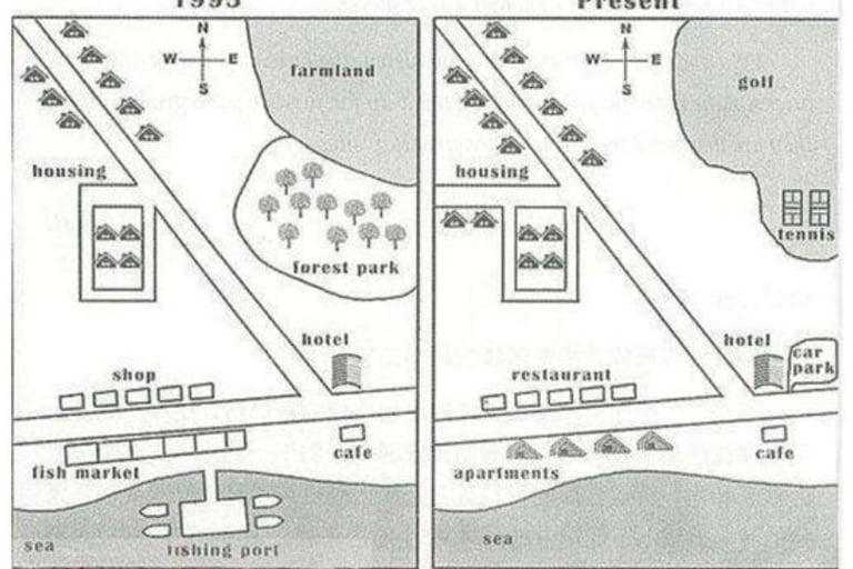
The maps illustrate the changes in the town’s transport infrastructure over a 25-year period. Overall, the town has developed significantly, with new roads, a railway line, and recreational facilities, although some older structures have been removed.
In 2000, the town featured a main road running from north to south, connecting the residential area in the north with the industrial zone in the south. There was also a small railway station near the town center, but it was not directly connected to the main residential or commercial areas.
By 2025, a new railway line extends eastward, linking the town center with the neighboring city. Additionally, a ring road has been constructed around the town, easing traffic congestion in the central areas. Several new bus stops have been introduced along major routes, improving public transport access. Recreational areas, such as a park near the river, have replaced some unused industrial land. Overall, the infrastructure changes reflect the town’s growth and modernization.
Band 7 Vocabulary: illustrates, developed, infrastructure, congestion, modernization, recreational facilities, residential area, industrial zone, extends, replaces
Band 8 Answer
The diagrams compare the town’s transport network in 2000 and 2025, highlighting significant improvements in connectivity and urban planning. It is evident that the town has shifted from a modest, centralized layout to a more integrated and accessible system.
In 2000, the town had a straightforward road system with a primary north-south route connecting residential neighborhoods in the north to the industrial sector in the south. The railway station was situated near the town center, but its utility was limited due to the absence of direct links to key areas. Public transport options were scarce, and traffic congestion was likely in the central district.
By 2025, major infrastructural developments are apparent. A new eastbound railway line has been introduced, connecting the town with nearby urban centers. A ring road encircles the town, diverting traffic from the inner streets and enhancing overall mobility. Several new bus stops have been strategically positioned along main routes, making public transport more efficient. Furthermore, parts of the old industrial land have been transformed into parks and recreational zones, indicating a focus on sustainable urban development. These changes demonstrate the town’s efforts to improve both connectivity and residents’ quality of life.
Band 8 Vocabulary: diagrams compare, highlighting, connectivity, urban planning, integrated system, straightforward, utility, scarce, infrastructural developments, encircles, diverting, strategically positioned, sustainable urban development, quality of life