explore now

CITY OR DEVELOPMENT OVER TIME
Band 7 Answer:
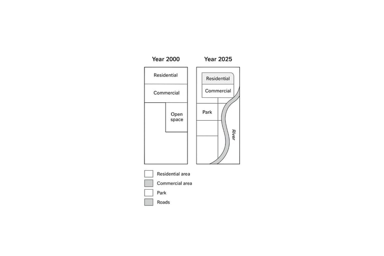
The maps illustrate the development of a city between 2000 and 2025. Overall, there has been noticeable urban growth, with residential and commercial areas expanding, and the road network being improved.
In 2000, the residential area was situated in the north, while the commercial center was small and located in the middle of the city. The south consisted of a large open space, and the river ran along the eastern edge. Only a few roads connected the main areas, making access limited.
By 2025, the residential area had expanded southward, occupying part of the previously open space. The commercial center was enlarged and slightly relocated to the east, reflecting growth in economic activities. Several new roads were built, linking residential and commercial zones more efficiently. Additionally, a new park was created in the southern part, providing recreational space for residents.
Overall, the maps indicate clear urban expansion, better connectivity, and improved amenities. The city has become more organized, functional, and visually structured over the 25-year period.
Band 8 Answer:
The maps compare the layout of a city in 2000 and 2025, highlighting significant urban development over the 25-year period. Overall, the city has experienced substantial residential and commercial expansion, along with improved infrastructure and recreational facilities.
In 2000, the residential area was confined to the northern part, while the commercial center was small and centrally located. The south of the city was largely open land, and a river ran along the eastern boundary. Only a few roads connected the main areas, limiting accessibility and circulation.
By 2025, the residential zone had expanded southward, taking over some of the previously open space. The commercial center had been enlarged and shifted slightly east, reflecting increased economic activity. An extensive network of roads was constructed, connecting all major areas and improving overall mobility. In addition, a new park was introduced in the southern part, enhancing the city’s recreational provision and aesthetic appeal. The river remained unchanged, maintaining its position along the eastern edge.
Overall, the maps clearly show a well-planned urban transformation. Residential and commercial growth, improved connectivity through new roads, and the addition of a recreational park indicate careful development planning. The city is now more structured, functional, and better equipped to meet the needs of its population compared to its layout in 2000.